search for books and compare prices
National Geographic Maps has written 557 work(s)
Search for other authors with the same name
at beginning |
displaying 1 to 25 |
next 25 >
show results in order: alphabetically | oldest to newest | newest to oldest


Paperback:
9781566954150 | Fol lam ma edition (Natl Geographic Maps, January 1, 1992), cover price $11.95 | About this edition: ⢠Waterproof ⢠Tear-Resistant ⢠Topographic MapCoverage includes Dixie National Forest.

Paperback:
9781566953702 | Fol lam ma edition (Natl Geographic Maps, January 1, 1994), cover price $11.95

Paperback:
9781566953306 | Fol lam ma edition (Natl Geographic Maps, January 1, 1995), cover price $11.95
Paperback:
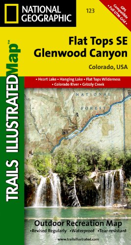
9781566952842 | Fol lam ma edition (Natl Geographic Maps, January 1, 1996), cover price $11.95 | About this edition: ⢠Waterproof ⢠Tear-Resistant ⢠Topographic MapCoverage includes White River National Forest; Flat Tops Wilderness; Deep Creek Recreational Area; Eagle and Colorado rivers; Coffee Pot Lakes, Heart, Haypress, Hanging and Sweetwater lakes; Tibbett's Ridge; Glenwood Canyon Trail; and Cottonwood Pass.

Paperback:
9781566952781 | Fol lam ma edition (Natl Geographic Maps, January 1, 1996), cover price $11.95 | About this edition: ⢠Waterproof ⢠Tear-Resistant ⢠Topographic MapCoverage includes White River and Routt national forests; Flat Tops Wilderness; Stillwater and Yamcolo reservoirs; the North Fork of the White River; and Marvine, Twin, Island, Trappers and Mirror lakes; Mandall and Indian Camp Pass; Big Marvine Peak.

Paperback:
9781566953733 | Fol map re edition (Natl Geographic Maps, January 1, 1996), cover price $11.95

Paperback:
9781566953092, titled "National Geographic Trails Illustrated Topographic Map Taos Wheeler Peak, New Mexico: New Mexico" | Fol lam ma edition (Natl Geographic Maps, January 1, 1996), cover price $11.95
Paperback:
9781566954112 | Fol lam ma edition (Natl Geographic Maps, January 1, 1997), cover price $11.95
Paperback:
9781566953825 | Fol lam ma edition (Natl Geographic Maps, January 1, 1997), cover price $11.95
Learn about these giant creatures of the sea with a map that introduces 17 different whale species. Each whale is drawn to scale and includes scientific names and information about their size, feeding patterns, and history.The map is packaged in a two inch diamater clear plastic tube. The tube has a decorative label showing a thumbnail of the map with dimensions and other pertinent information. Sheet Size = 29.75" x 21"
Paperback:
9780792297420 | Map edition (Natl Geographic Maps, January 1, 1998), cover price $10.99
9780792249849 | Rol map edition (Natl Geographic Maps, January 1, 1998), cover price $14.99 | About this edition: Learn about these giant creatures of the sea with a map that introduces 17 different whale species.

Paperback:
9781566954488 | Fol lam ma edition (Natl Geographic Maps, January 1, 1998), cover price $11.95
Paperback:
9781566953955 | Fol lam ma edition (Natl Geographic Maps, January 1, 1998), cover price $11.95

Paperback:
9781566953023 | Fol lam ma edition (Natl Geographic Maps, January 1, 1998), cover price $11.95 | About this edition: ⢠Waterproof ⢠Tear-Resistant ⢠Topographic MapThe remnant of a volcano and known for its remarkably blue water, Crater Lake is the deepest lake in the United States.

Paperback:
9781566950893 | Fol lam ma edition (Natl Geographic Maps, January 1, 1999), cover price $8.99
Paperback:
9781597751988 | Map edition (Natl Geographic Maps, January 1, 1999), cover price $10.99

Paperback:
9781566954099, titled "National Geographic Trails Illustrated Map Everglades National Park, Florida, USA: Ng.np.243" | Fol map re edition (Natl Geographic Maps, January 1, 1999), cover price $11.95 | About this edition: ⢠Waterproof ⢠Tear-Resistant ⢠Topographic MapVisited by more than 1 million people a year, Everglades National Park has one of the world's most diverse ecosystems and is an international treasure.

Paperback:
9780792249801 | Rol map edition (Natl Geographic Maps, January 1, 1999), cover price $14.99
Paperback:
9781566950749 | Fol lam ma edition (Natl Geographic Maps, January 1, 1999), cover price $11.95
Paperback:
9781566950862 | Map edition (Natl Geographic Maps, January 1, 1999), cover price $8.99 | also contains National Geographic Madrid
Paperback:
9781566950879 | Fol map edition (Natl Geographic Maps, January 1, 1999), cover price $8.99
Paperback:
9781566952774 | Fol lam ma edition (Natl Geographic Maps, January 1, 1999), cover price $11.95

Paperback:
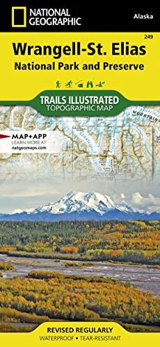
9781566953863, titled "National Geographic Trails Illustrated Topographic Glacier Bay National Park and Preserve: Alaska" | Fol lam ma edition (Natl Geographic Maps, January 1, 1999), cover price $11.95 | About this edition: ⢠Waterproof ⢠Tear-Resistant ⢠Topographic MapNational Geographicâs Trails Illustrated map of Glacier Bay National Park and Preserve in Alaska's panhandle is perfect for hiking, camping, boating, paddling, and wildlife viewing in this scenic, rugged frontier.

Paperback:
9781572624351 | Fol lam ma edition (Natl Geographic Maps, January 1, 2003), cover price $6.99 | also contains National Geographic Alabama | About this edition: ⢠Waterproof ⢠Tear-Resistant ⢠Travel MapThe front side is an easy-to-read road map with insets of: - Huntsville - Tuscaloosa - Phenix City The back includes: - Information and maps for Birmingham, Mobile, and Montgomery - Points of interest - Scenic drive - Park service sites in AlabamaFold Size = 2.

Paperback:
9781566955201 | Fol lam ma edition (Natl Geographic Maps, January 1, 2000), cover price $11.95

Paperback:
9781566954044 | Fol map edition (Natl Geographic Maps, January 1, 2000), cover price $11.95
at beginning |
displaying 1 to 25 |
next 25 >