search for books and compare prices
Rand McNally Regional Map Minneapolis / St. Paul, Minnesota
By
Rand McNally and Company (corporate author)
Price
Store
Arrives
Preparing
Shipping
Jump quickly to results on these stores:
The price is the lowest for any condition, which may be new or used; other conditions may also be available.
Jump down to see edition details for: Paperback
Bibliographic Detail
Publisher
Rand McNally
Publication date
May 16, 2014
Binding
Paperback
Edition
Fol map
Book category
Adult Non-Fiction
ISBN-13
9780528008832
ISBN-10
0528008838
Dimensions
0.25 by 4.25 by 8.75 in.
Weight
0.15 lbs.
Original list price
$6.99
Other format details
map
Amazon.com says people who bought this book also bought:
Moon Minneapolis & St. Paul | Moon Minneapolis & St. Paul | Newcomer's Handbook for Moving to and Living in Minneapolis St. Paul | Rand McNally Easy to Read! Minnesota | Rand McNally Minnesota Easyfinder Map | Minnesota Atlas and Gazetteer | Walking Twin Cities
Moon Minneapolis & St. Paul | Moon Minneapolis & St. Paul | Newcomer's Handbook for Moving to and Living in Minneapolis St. Paul | Rand McNally Easy to Read! Minnesota | Rand McNally Minnesota Easyfinder Map | Minnesota Atlas and Gazetteer | Walking Twin Cities


Summaries and Reviews
Amazon.com description: Product Description: Rand McNally's folded map for Minneapolis St. Paul is a must-have for anyone traveling in and around the Minneapolis St. Paul area, offering unbeatable accuracy and reliability at a great price. Our trusted cartography shows all Interstate, U.S., state, and county highways, along with clearly indicated parks, points of interest, airports, county boundaries, and streets. The easy-to-use legend and detailed index make for quick and easy location of destinations. You'll see why Rand McNally folded maps have been the trusted standard for years.
Folded map features:
Regularly updated
Full-color maps
Clearly labeled Interstate, U.S., state, and county highways
Indications of parks, points of interest, airports, county boundaries, downtown & vicinity maps
Easy-to-use legend
Convenient folded size
© 2014
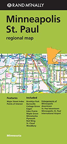
Additional Features:
Major Street Index
Points of Interest
Enlargements of Minneapolis downtown
St. Paul downtown
Minneapolis-St. Paul International Airport
Communities Included: Brooklyn Park, Burnsville, Cottage Grove, Eagan, Eden Prairie, Maple Grove, Minnetonka, Plymouth, Red Wing, St. Could, Woodbury
Folded map features:
Regularly updated
Full-color maps
Clearly labeled Interstate, U.S., state, and county highways
Indications of parks, points of interest, airports, county boundaries, downtown & vicinity maps
Easy-to-use legend
Convenient folded size
© 2014
Additional Features:
Major Street Index
Points of Interest
Enlargements of Minneapolis downtown
St. Paul downtown
Minneapolis-St. Paul International Airport
Communities Included: Brooklyn Park, Burnsville, Cottage Grove, Eagan, Eden Prairie, Maple Grove, Minnetonka, Plymouth, Red Wing, St. Could, Woodbury
Editions
Paperback

The price comparison is for this edition
Fol map edition from Rand McNally (May 16, 2014)
9780528008832 | details & prices | 4.25 × 8.75 × 0.25 in. | 0.15 lbs | List price $6.99
About: Rand McNally's folded map for Minneapolis St.
About: Rand McNally's folded map for Minneapolis St.
Pricing is shown for items sent to or within the U.S., excluding shipping and tax. Please consult the store to determine exact fees. No warranties are made express or implied about the accuracy, timeliness, merit, or value of the information provided. Information subject to change without notice. isbn.nu is not a bookseller, just an information source.